290 Pennant Ave
Lathrop, CA 95330
- 5Beds
- 3Baths
- 2,841ft²Living Area
- 4,092ft²Lot Size
- -Pool
- 2Car
- 2006Year Built
- -DOM
- 3Permits
Property Valuations
Latest estimates for 290 Pennant Ave based on TopHap automated valuation model (AVM).
TopHap Estimate
$689,250
$242/ft²
+$157K above Sold Price
Updated 6 months ago
Last Sold Price
$532,036
$187/ft²
18 years ago
290 Pennant Ave is valued at $689,250 by TopHap AVM 6 months ago.
290 Pennant Ave was last sold in 2006 for $532,036.
Permits
290 Pennant Ave has 3 permit records.
Current Ownership
Information about the current owner(s).
Taxes Billed
Taxes billed in 2023$8,890.72From latest Total Assessed Value1.43%Total Assessed Value$622,000=Land+
Assessed Value$90,000Additions
Assessed Value$532,000
In 2023, taxes billed for 290 Pennant Ave were $8,890.72, which is 1.43% from latest Total Assessed Value of $622,000.
Property History
290 Pennant Ave has undefined property events records (listings, deeds, permits, tax, foreclosure, loan).
Environment
Environmental factors around 290 Pennant Ave
Hazard Risks
Earthquake179Nat'l Avg100Particulates97Air Pollution85Ozone82Carb Mono80Lead37Tornado22Weather8Wind2Hail0Hurricane0
10 hazards (Carbon Monoxide, Earthquake Risk, Tornado Index, Air Pollution Index, Ozone Index, Wind Index, Weather Risk, Lead Index, Particulate Matter, National Average) are above the national average around 290 Pennant Ave.
Walkability Index
15 /20
Most Walkable
20-18
Very Walkable
17-15
Somewhat Walkable
14-10
Car Dependent
9-0
290 Pennant Ave has a walkability score of 15 out of 20, which means that it is in a very walkable area.
Noise Level
35 dB
Quiet Suburban Residential 0-49
Suburban Residential 50-54
Urban Residential 55-59
Noisy Urban Residential 60-64
Very Noisy Urban Residential 65+
Noise at 290 Pennant Ave is around 35dBs, which is comparable to a Quiet Suburban Residential area.
Temperature
Seasonal temperature sampled over multiple years
Winter
Average
Low
38°F
High
56°F
Summer
Average
Low
57°F
High
91°F
In the winter at 290 Pennant Ave, temperatures range from 38.21°F to 56.42°F with an average of 47.32°F. In the summer, the temperature ranges from 57.07°F to 90.9°F with and average of 73.99°F.
School Information
Public/private schools serving 290 Pennant Ave
Public Schools
Nearby public schools serving 290 Pennant Ave have ratings undefined, and undefined.
Neighborhood
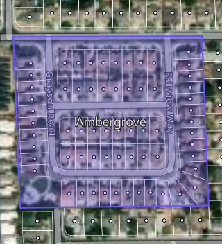
This property is located in Ambergrove, Lathrop, CA 95330.
Seasonal Housing units 95330
13%of housing is for seasonal rent.
Daytime Population for 95330
-11%of people during work hours.
Boundary map of Ambergrove.
Crime Index for 95330
75
The crime index in 95330 is 75, which is 0.8 times lower than national average.
Market Trends
Historical market data near 290 Pennant Ave over selected time period.
Nearby Properties on Pennant Ave
- 293 Pennant Ave, Lathrop, CA 95330 (Ambergrove) is a 2,528 square foot, 4 bedroom, 2 bathroom, 0.09 acre property. It was built in 2006 and has an estimate of $611,460 with a price per ft² of $242.
- 301 Pennant Ave, Lathrop, CA 95330 (Ambergrove) is a 2,160 square foot, 3 bedroom, 2 bathroom, 0.11 acre property. It was built in 2006 and has an estimate of $582,291 with a price per ft² of $270.
- 302 Pennant Ave, Lathrop, CA 95330 (Ambergrove) is a 2,033 square foot, 3 bedroom, 3 bathroom, 0.09 acre property. It was built in 2006 and has an estimate of $571,524 with a price per ft² of $281.
- 314 Pennant Ave, Lathrop, CA 95330 (Ambergrove) is a 2,417 square foot, 3 bedroom, 2 bathroom, 0.11 acre property. It was built in 2006 and has an estimate of $567,534 with a price per ft² of $235.
- 277 Pennant Ave, Lathrop, CA 95330 (Ambergrove) is a 2,033 square foot, 3 bedroom, 2 bathroom, 0.09 acre property. It was built in 2006 and has an estimate of $556,602 with a price per ft² of $274.
- 278 Pennant Ave, Lathrop, CA 95330 (Ambergrove) is a 2,160 square foot, 4 bedroom, 2 bathroom, 0.09 acre property. It was built in 2006 and has an estimate of $542,175 with a price per ft² of $251.
- 220 Pennant Ave, Lathrop, CA 95330 (Ambergrove) is a 2,841 square foot, 5 bedroom, 3 bathroom, 0.09 acre property. It was built in 2006 and has an estimate of $654,647 with a price per ft² of $230.
- 290 Pennant Ave, Lathrop, CA 95330 (Ambergrove) is a 2,841 square foot, 5 bedroom, 3 bathroom, 0.09 acre property. It was built in 2006 and has an estimate of $636,320 with a price per ft² of $224.
- 208 Pennant Ave, Lathrop, CA 95330 (Ambergrove) is a 2,160 square foot, 3 bedroom, 2 bathroom, 0.12 acre property. It was built in 2006 and has an estimate of $588,579 with a price per ft² of $272.
- 238 Pennant Ave, Lathrop, CA 95330 (Ambergrove) is a 2,033 square foot, 3 bedroom, 2 bathroom, 0.09 acre property. It was built in 2006 and has an estimate of $567,730 with a price per ft² of $279.
- 266 Pennant Ave, Lathrop, CA 95330 (Ambergrove) is a 2,417 square foot, 4 bedroom, 3 bathroom, 0.09 acre property. It was built in 2006 and has an estimate of $606,785 with a price per ft² of $251.
- 201 Pennant Ave, Lathrop, CA 95330 (Ambergrove) is a 2,130 square foot, 3 bedroom, 3.25 bathroom, 0.11 acre property. It was built in 2017 and has an estimate of $585,685 with a price per ft² of $275.
- 215 Pennant Ave, Lathrop, CA 95330 (Ambergrove) is a 2,143 square foot, 3 bedroom, 2 bathroom, 0.09 acre property. It was built in 2017 and has an estimate of $626,650 with a price per ft² of $292.
- 229 Pennant Ave, Lathrop, CA 95330 (Ambergrove) is a 2,130 square foot, 4 bedroom, 2 bathroom, 0.09 acre property. It was built in 2017 and has an estimate of $622,158 with a price per ft² of $292.
- 243 Pennant Ave, Lathrop, CA 95330 (Ambergrove) is a 2,130 square foot, 3 bedroom, 2 bathroom, 0.09 acre property. It was built in 2017 and has an estimate of $613,342 with a price per ft² of $288.
- 261 Pennant Ave, Lathrop, CA 95330 (Ambergrove) is a 2,130 square foot, 4 bedroom, 2 bathroom, 0.09 acre property. It was built in 2017 and has an estimate of $624,559 with a price per ft² of $293.