196 Stanley Ct
Vacaville, CA 95687
- 4Beds
- 2Baths
- 1,602ft²Living Area
- 6,098ft²Lot Size
- 1Pool
- 2Car
- 1978Year Built
- -DOM
- 5Permits
Property Valuations
Latest estimates for 196 Stanley Ct based on TopHap automated valuation model (AVM).
TopHap Estimate
$580,500
$362/ft²
+$131K above Sold Price
Updated 7 months ago
Last Sold Price
$450,000
$281/ft²
4 years ago
196 Stanley Ct is valued at $580,500 by TopHap AVM 7 months ago.
196 Stanley Ct was last sold in 2020 for $450,000.
Permits
196 Stanley Ct has 5 permit records.
Current Ownership
Information about the current owner(s).
Taxes Billed
Taxes billed in 2023$5,444.00From latest Total Assessed Value1.15%Total Assessed Value$473,027=Land+
Assessed Value$136,651Additions
Assessed Value$336,376
In 2023, taxes billed for 196 Stanley Ct were $5,444, which is 1.15% from latest Total Assessed Value of $473,027.
Property History
196 Stanley Ct has undefined property events records (listings, deeds, permits, tax, foreclosure, loan).
Environment
Environmental factors around 196 Stanley Ct
Hazard Risks
Earthquake377Nat'l Avg100Particulates89Ozone87Carb Mono83Air Pollution83Lead45Tornado3Wind2Hail1Weather1Hurricane0
11 hazards (Carbon Monoxide, Earthquake Risk, Hail Index, Tornado Index, Air Pollution Index, Ozone Index, Wind Index, Weather Risk, Lead Index, Particulate Matter, National Average) are above the national average around 196 Stanley Ct.
Walkability Index
15 /20
Most Walkable
20-18
Very Walkable
17-15
Somewhat Walkable
14-10
Car Dependent
9-0
196 Stanley Ct has a walkability score of 15 out of 20, which means that it is in a very walkable area.
Temperature
Seasonal temperature sampled over multiple years
Winter
Average
Low
38°F
High
57°F
Summer
Average
Low
56°F
High
89°F
In the winter at 196 Stanley Ct, temperatures range from 38.47°F to 56.9°F with an average of 47.69°F. In the summer, the temperature ranges from 55.71°F to 89.04°F with and average of 72.38°F.
School Information
Public/private schools serving 196 Stanley Ct
Public Schools
Nearby public schools serving 196 Stanley Ct have ratings undefined, undefined, and undefined.
Neighborhood
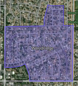
This property is located in Woodridge, Vacaville, CA 95687.
Seasonal Housing units 95687
13%of housing is for seasonal rent.
Daytime Population for 95687
-11%of people during work hours.
Boundary map of Woodridge.
Crime Index for 95687
71
The crime index in 95687 is 71, which is 0.7 times lower than national average.
Market Trends
Historical market data near 196 Stanley Ct over selected time period.
Nearby Properties on Stanley Ct
- 190 Stanley Ct, Vacaville, CA 95687 (Woodridge) is a 1,516 square foot, 3 bedroom, 2 bathroom, 0.13 acre property. It was built in 1978 and has an estimate of $546,722 with a price per ft² of $361.
- 178 Stanley Ct, Vacaville, CA 95687 (Woodridge) is a 1,318 square foot, 3 bedroom, 2 bathroom, 0.13 acre property. It was built in 1978 and has an estimate of $523,625 with a price per ft² of $397.
- 166 Stanley Ct, Vacaville, CA 95687 (Woodridge) is a 1,430 square foot, 4 bedroom, 2 bathroom, 0.16 acre property. It was built in 1978 and has an estimate of $526,620 with a price per ft² of $368.
- 184 Stanley Ct, Vacaville, CA 95687 (Woodridge) is a 1,430 square foot, 3 bedroom, 2 bathroom, 0.14 acre property. It was built in 1978 and has an estimate of $501,161 with a price per ft² of $350.
- 160 Stanley Ct, Vacaville, CA 95687 (Woodridge) is a 1,602 square foot, 3 bedroom, 2 bathroom, 0.24 acre property. It was built in 1978 and has an estimate of $547,980 with a price per ft² of $342.
- 154 Stanley Ct, Vacaville, CA 95687 (Woodridge) is a 1,318 square foot, 3 bedroom, 2 bathroom, 0.22 acre property. It was built in 1978 and has an estimate of $502,985 with a price per ft² of $382.
- 196 Stanley Ct, Vacaville, CA 95687 (Woodridge) is a 1,602 square foot, 4 bedroom, 2 bathroom, 0.14 acre property. It was built in 1978 and has an estimate of $492,101 with a price per ft² of $307.
- 148 Stanley Ct, Vacaville, CA 95687 (Woodridge) is a 960 square foot, 3 bedroom, 1 bathroom, 0.17 acre property. It was built in 1978 and has an estimate of $455,482 with a price per ft² of $474.
- 142 Stanley Ct, Vacaville, CA 95687 (Woodridge) is a 1,602 square foot, 3 bedroom, 2 bathroom, 0.21 acre property. It was built in 1978 and has an estimate of $489,823 with a price per ft² of $306.
- 136 Stanley Ct, Vacaville, CA 95687 (Woodridge) is a 1,430 square foot, 4 bedroom, 2 bathroom, 0.2 acre property. It was built in 1978 and has an estimate of $504,054 with a price per ft² of $352.
- 130 Stanley Ct, Vacaville, CA 95687 (Woodridge) is a 1,296 square foot, 3 bedroom, 2 bathroom, 0.19 acre property. It was built in 1978 and has an estimate of $542,558 with a price per ft² of $419.
- 124 Stanley Ct, Vacaville, CA 95687 (Woodridge) is a 1,318 square foot, 3 bedroom, 2 bathroom, 0.19 acre property. It was built in 1979 and has an estimate of $538,286 with a price per ft² of $408.
- 118 Stanley Ct, Vacaville, CA 95687 (Woodridge) is a 1,602 square foot, 3 bedroom, 2 bathroom, 0.16 acre property. It was built in 1978 and has an estimate of $556,303 with a price per ft² of $347.
- 172 Stanley Ct, Vacaville, CA 95687 (Woodridge) is a 2,064 square foot, 3 bedroom, 2 bathroom, 0.14 acre property. It was built in 1978 and has an estimate of $544,443 with a price per ft² of $264.
- 100 Stanley Ct, Vacaville, CA 95687 (Woodridge) is a 1,430 square foot, 4 bedroom, 2 bathroom, 0.19 acre property. It was built in 1978 and has an estimate of $558,282 with a price per ft² of $390.
- 106 Stanley Ct, Vacaville, CA 95687 (Woodridge) is a 1,318 square foot, 3 bedroom, 2 bathroom, 0.16 acre property. It was built in 1978 and has an estimate of $519,922 with a price per ft² of $394.
- 112 Stanley Ct, Vacaville, CA 95687 (Woodridge) is a 1,430 square foot, 4 bedroom, 2 bathroom, 0.14 acre property. It was built in 1978 and has an estimate of $529,021 with a price per ft² of $370.