15 Ashmont Ct
Silver Spring, MD 20906
- -Bed
- 4Baths
- 1,628ft²Living Area
- 1,540ft²Lot Size
- -Pool
- -Car
- 1984Year Built
- -DOM
- 1Permit
Property Valuations
Latest estimates for 15 Ashmont Ct based on TopHap automated valuation model (AVM).
TopHap Estimate
$514,320
$315/ft²
+$378K above Sold Price
Updated 6 months ago
Last Sold Price
$135,950
$84/ft²
26 years ago
15 Ashmont Ct is valued at $514,320 by TopHap AVM 6 months ago.
15 Ashmont Ct was last sold in 1998 for $135,950.
Permits
15 Ashmont Ct has 1 permit records.
Current Ownership
Information about the current owner(s).
Taxes Billed
Taxes billed in 2022$3,246.28From latest Total Assessed Value0.94%Total Assessed Value$345,100=Land+
Assessed Value$0Additions
Assessed Value$0
In 2022, taxes billed for 15 Ashmont Ct were $3,246.28, which is 0.94% from latest Total Assessed Value of $345,100.
Property History
15 Ashmont Ct has undefined property events records (listings, deeds, permits, tax, foreclosure, loan).
Environment
Environmental factors around 15 Ashmont Ct
Hazard Risks
Wind177Nat'l Avg100Carb Mono91Air Pollution91Ozone89Hurricane86Weather86Hail84Tornado78Particulates77Lead40Earthquake34
12 hazards (Carbon Monoxide, Earthquake Risk, Hail Index, Tornado Index, Hurricane Index, Air Pollution Index, Ozone Index, Wind Index, Weather Risk, Lead Index, Particulate Matter, National Average) are above the national average around 15 Ashmont Ct.
Walkability Index
14 /20
Most Walkable
20-18
Very Walkable
17-15
Somewhat Walkable
14-10
Car Dependent
9-0
15 Ashmont Ct has a walkability score of 14 out of 20, which means that it is in a somewhat walkable area.
Temperature
Seasonal temperature sampled over multiple years
Winter
Average
Low
26°F
High
44°F
Summer
Average
Low
63°F
High
84°F
In the winter at 15 Ashmont Ct, temperatures range from 25.67°F to 43.82°F with an average of 34.75°F. In the summer, the temperature ranges from 62.79°F to 84.04°F with and average of 73.42°F.
School Information
Public/private schools serving 15 Ashmont Ct
Public Schools
Nearby public schools serving 15 Ashmont Ct have ratings undefined, undefined, undefined, undefined, undefined, undefined, undefined, undefined, undefined, and undefined.
Neighborhood
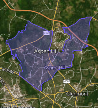
This property is located in Aspen Hill, Silver Spring, MD 20906.
Seasonal Housing units 20906
7%of housing is for seasonal rent.
Daytime Population for 20906
-27%of people during work hours.
Boundary map of Aspen Hill.
Crime Index for 20906
104
The crime index in 20906 is 104, which is 1.0 times higher than national average.
Market Trends
Historical market data near 15 Ashmont Ct over selected time period.
Nearby Properties on Ashmont Ct
- 2 Ashmont Ct, Silver Spring, MD 20906 (Aspen Hill) is a 1,540 square foot, 3.25 bathroom, 0.04 acre property. It was built in 1984 and has an estimate of $447,645 with a price per ft² of $291.
- 10 Ashmont Ct, Silver Spring, MD 20906 (Aspen Hill) is a 1,540 square foot, 3.25 bathroom, 0.05 acre property. It was built in 1984 and has an estimate of $466,953 with a price per ft² of $303.
- 4 Ashmont Ct, Silver Spring, MD 20906 (Aspen Hill) is a 1,628 square foot, 3.25 bathroom, 0.04 acre property. It was built in 1984 and has an estimate of $439,155 with a price per ft² of $270.
- 6 Ashmont Ct, Silver Spring, MD 20906 (Aspen Hill) is a 1,540 square foot, 4.25 bathroom, 0.04 acre property. It was built in 1984 and has an estimate of $441,209 with a price per ft² of $286.
- 8 Ashmont Ct, Silver Spring, MD 20906 (Aspen Hill) is a 1,628 square foot, 3.25 bathroom, 0.04 acre property. It was built in 1984 and has an estimate of $439,155 with a price per ft² of $270.
- 25 Ashmont Ct, Silver Spring, MD 20906 (Aspen Hill) is a 1,540 square foot, 3.25 bathroom, 0.04 acre property. It was built in 1984 and has an estimate of $440,250 with a price per ft² of $286.
- 21 Ashmont Ct, Silver Spring, MD 20906 (Aspen Hill) is a 1,540 square foot, 3.25 bathroom, 0.04 acre property. It was built in 1984 and has an estimate of $436,005 with a price per ft² of $283.
- 5 Ashmont Ct, Silver Spring, MD 20906 (Aspen Hill) is a 1,540 square foot, 3.25 bathroom, 0.04 acre property. It was built in 1984 and has an estimate of $471,198 with a price per ft² of $306.
- 19 Ashmont Ct, Silver Spring, MD 20906 (Aspen Hill) is a 1,628 square foot, 3.25 bathroom, 0.04 acre property. It was built in 1984 and has an estimate of $443,674 with a price per ft² of $273.
- 23 Ashmont Ct, Silver Spring, MD 20906 (Aspen Hill) is a 1,628 square foot, 3.25 bathroom, 0.04 acre property. It was built in 1984 and has an estimate of $439,429 with a price per ft² of $270.
- 13 Ashmont Ct, Silver Spring, MD 20906 (Aspen Hill) is a 1,628 square foot, 3.25 bathroom, 0.05 acre property. It was built in 1984 and has an estimate of $438,607 with a price per ft² of $269.
- 27 Ashmont Ct, Silver Spring, MD 20906 (Aspen Hill) is a 1,628 square foot, 3.25 bathroom, 0.05 acre property. It was built in 1984 and has an estimate of $436,964 with a price per ft² of $268.
- 9 Ashmont Ct, Silver Spring, MD 20906 (Aspen Hill) is a 1,540 square foot, 4.25 bathroom, 0.05 acre property. It was built in 1984 and has an estimate of $432,856 with a price per ft² of $281.
- 15 Ashmont Ct, Silver Spring, MD 20906 (Aspen Hill) is a 1,628 square foot, 4.25 bathroom, 0.04 acre property. It was built in 1984 and has an estimate of $448,056 with a price per ft² of $275.
- 7 Ashmont Ct, Silver Spring, MD 20906 (Aspen Hill) is a 1,628 square foot, 3.25 bathroom, 0.04 acre property. It was built in 1984 and has an estimate of $443,126 with a price per ft² of $272.
- 1 Ashmont Ct, Silver Spring, MD 20906 (Aspen Hill) is a 1,628 square foot, 4.25 bathroom, 0.05 acre property. It was built in 1984 and has an estimate of $462,571 with a price per ft² of $284.
- 3 Ashmont Ct, Silver Spring, MD 20906 (Aspen Hill) is a 1,628 square foot, 3.25 bathroom, 0.04 acre property. It was built in 1984 and has an estimate of $416,000 with a price per ft² of $256.
- 17 Ashmont Ct, Silver Spring, MD 20906 (Aspen Hill) is a 1,540 square foot, 3.25 bathroom, 0.04 acre property. It was built in 1984 and has an estimate of $424,001 with a price per ft² of $275.