179 Randall Ave
Vacaville, CA 95687
- 4Beds
- 2Baths
- 1,470ft²Living Area
- 7,840ft²Lot Size
- -Pool
- 2Car
- 1976Year Built
- -DOM
- 4Permits
Property Valuations
Latest estimates for 179 Randall Ave based on TopHap automated valuation model (AVM).
TopHap Estimate
$581,500
$395/ft²
+$397K above Sold Price
Updated 7 months ago
Last Sold Price
$185,000
$126/ft²
24 years ago
179 Randall Ave is valued at $581,500 by TopHap AVM 7 months ago.
179 Randall Ave was last sold in 2000 for $185,000.
Permits
179 Randall Ave has 4 permit records.
Current Ownership
Information about the current owner(s).
Taxes Billed
Taxes billed in 2023$3,139.02From latest Total Assessed Value1.17%Total Assessed Value$267,938=Land+
Assessed Value$57,929Additions
Assessed Value$210,009
In 2023, taxes billed for 179 Randall Ave were $3,139.02, which is 1.17% from latest Total Assessed Value of $267,938.
Property History
179 Randall Ave has undefined property events records (listings, deeds, permits, tax, foreclosure, loan).
Environment
Environmental factors around 179 Randall Ave
Hazard Risks
Earthquake377Nat'l Avg100Particulates89Ozone87Carb Mono83Air Pollution83Lead45Tornado3Wind2Hail1Weather1Hurricane0
11 hazards (Carbon Monoxide, Earthquake Risk, Hail Index, Tornado Index, Air Pollution Index, Ozone Index, Wind Index, Weather Risk, Lead Index, Particulate Matter, National Average) are above the national average around 179 Randall Ave.
Walkability Index
16 /20
Most Walkable
20-18
Very Walkable
17-15
Somewhat Walkable
14-10
Car Dependent
9-0
179 Randall Ave has a walkability score of 16 out of 20, which means that it is in a very walkable area.
Temperature
Seasonal temperature sampled over multiple years
Winter
Average
Low
38°F
High
57°F
Summer
Average
Low
56°F
High
89°F
In the winter at 179 Randall Ave, temperatures range from 38.47°F to 56.9°F with an average of 47.69°F. In the summer, the temperature ranges from 55.71°F to 89.04°F with and average of 72.38°F.
School Information
Public/private schools serving 179 Randall Ave
Public Schools
Nearby public schools serving 179 Randall Ave have ratings undefined, undefined, and undefined.
Neighborhood
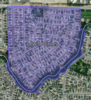
This property is located in Lewis Homes, Vacaville, CA 95687.
Seasonal Housing units 95687
13%of housing is for seasonal rent.
Daytime Population for 95687
-11%of people during work hours.
Boundary map of Lewis Homes.
Crime Index for 95687
71
The crime index in 95687 is 71, which is 0.7 times lower than national average.
Market Trends
Historical market data near 179 Randall Ave over selected time period.
Nearby Properties on Randall Ave
- 100 Randall Ave, Vacaville, CA 95687 (Lewis Homes) is a 1,513 square foot, 3 bedroom, 2 bathroom, 0.18 acre property. It was built in 1975 and has an estimate of $549,097 with a price per ft² of $363.
- 107 Randall Ave, Vacaville, CA 95687 (Lewis Homes) is a 1,924 square foot, 3 bedroom, 2 bathroom, 0.16 acre property. It was built in 1975 and has an estimate of $573,211 with a price per ft² of $298.
- 113 Randall Ave, Vacaville, CA 95687 (Lewis Homes) is a 1,513 square foot, 3 bedroom, 2 bathroom, 0.19 acre property. It was built in 1975 and has an estimate of $542,938 with a price per ft² of $359.
- 101 Randall Ave, Vacaville, CA 95687 (Lewis Homes) is a 1,513 square foot, 3 bedroom, 2 bathroom, 0.21 acre property. It was built in 1975 and has an estimate of $538,870 with a price per ft² of $356.
- 130 Randall Ave, Vacaville, CA 95687 (Lewis Homes) is a 1,806 square foot, 4 bedroom, 2 bathroom, 0.15 acre property. It was built in 1975 and has an estimate of $549,071 with a price per ft² of $304.
- 136 Randall Ave, Vacaville, CA 95687 (Lewis Homes) is a 1,374 square foot, 3 bedroom, 2 bathroom, 0.16 acre property. It was built in 1975 and has an estimate of $533,809 with a price per ft² of $389.
- 142 Randall Ave, Vacaville, CA 95687 (Lewis Homes) is a 1,260 square foot, 3 bedroom, 2 bathroom, 0.13 acre property. It was built in 1975 and has an estimate of $524,469 with a price per ft² of $416.
- 154 Randall Ave, Vacaville, CA 95687 (Lewis Homes) is a 1,806 square foot, 4 bedroom, 2 bathroom, 0.13 acre property. It was built in 1975 and has an estimate of $553,647 with a price per ft² of $307.
- 196 Randall Ave, Vacaville, CA 95687 (Lewis Homes) is a 1,374 square foot, 3 bedroom, 2 bathroom, 0.18 acre property. It was built in 1976 and has an estimate of $555,781 with a price per ft² of $404.
- 236 Randall Ave, Vacaville, CA 95687 (Lewis Homes) is a 1,470 square foot, 4 bedroom, 2 bathroom, 0.17 acre property. It was built in 1976 and has an estimate of $504,774 with a price per ft² of $343.
- 239 Randall Ave, Vacaville, CA 95687 (Lewis Homes) is a 1,513 square foot, 3 bedroom, 2 bathroom, 0.19 acre property. It was built in 1976 and has an estimate of $494,266 with a price per ft² of $327.
- 233 Randall Ave, Vacaville, CA 95687 (Lewis Homes) is a 1,430 square foot, 3 bedroom, 2 bathroom, 0.14 acre property. It was built in 1976 and has an estimate of $438,271 with a price per ft² of $306.
- 221 Randall Ave, Vacaville, CA 95687 (Lewis Homes) is a 1,260 square foot, 3 bedroom, 2 bathroom, 0.15 acre property. It was built in 1976 and has an estimate of $513,284 with a price per ft² of $407.
- 215 Randall Ave, Vacaville, CA 95687 (Lewis Homes) is a 1,513 square foot, 3 bedroom, 2 bathroom, 0.15 acre property. It was built in 1976 and has an estimate of $520,934 with a price per ft² of $344.
- View more properties on Randall Ave